
Description
High stability GNSS aided Inertial Navigation System (INS) that provides accurate and reliable Position, Velocity, Time (PVT) and Attitude (roll, pitch, yaw) under the most demanding conditions.
It contains an 9-axis MEMS IMU (Cost-effective IMU or High Stability IMU), single antenna multi-constellation multi-frequency OEM GNSS module and interfaces module that have embedded MCUs with algorithms for Extended Kalman Filter, PPP and RTK-engine.
The robust loosely-coupled GNSS+INS integration provides superior performance during GNSS signal outages that makes it ideal solution for systems requiring continuous positioning. The raw GNSS measurements are available for user’s secondary processing as well as API functions for his/her developments.
Different types of wireless (GSM/LTE, Wi-Fi, NB IoT, LoRA, UHF) and wired (Ethernet, RS422) interfaces may be available for interested user. They allow to accept signals from various Differential Correction Services.
Use our software tool designed to full control and management of the GNSS receiver.
Our technical support will answer all questions and help with equipment setup.
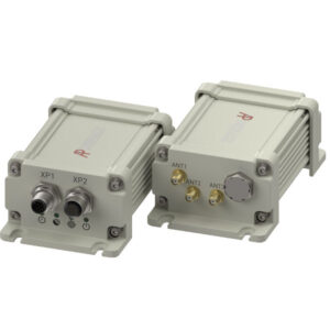
It has four hardware options:
A: cost-effective IMU-based, without wireless interface
B: cost-effective IMU-based, with wireless interface
C: high stability IMU-based, without wireless interface
D: high stability IMU-based, with wireless interface
TECHNICAL SPECIFICATIONS
| Supported navigation systems | GPS L1, L2/L5
GLONASS G1, G2 Galileo E1, E5a/E5b BeiDou B1, B2 NavIC L5/S-band1 |
||
| Supported SBAS systems | WAAS
EGNOS GAGAN MSAS |
||
| Position data update rate | |||
| Standalone mode | 20 (1, 5, 10) Hz | ||
| RTK mode | 20 (1, 5, 10) Hz | ||
| PPP mode | 20 (1, 5, 10) Hz | ||
| GNSS+INS mode | Up to 150 Hz | ||
| Raw data update rate | 20 (1, 5, 10) Hz | ||
| Time to first fix | |||
| Cold start | < 60 s | ||
| Re-acquisition | < 2 s | ||
| Timing accuracy | +/- 15 ns | ||
| Accuracy (RMS) | Horizontal | Vertical | |
| Position | – Standalone mode | 1.5 m | 2 m |
| – SBAS+GPS mode | 0.6 m | 0.8 m | |
| – RTK mode | 0.005 m + 0.5 ppm | 0.008 m + 1.0 ppm | |
| – PPP mode | 0.05 m | 0.1 m | |
| Velocity | 0.02 m/s | 0.03 m/s | |
| Orientation angles accuracy | |||
| Heading | <1° | ||
| Pitch | <1° | ||
| Roll | <1° | ||
| Interfaces | 2 х RS422, Ethernet2, CAN2 | ||
| Interface protocols | RTCM 3.3 (MSM, Legacy messages, SSR correction)
NMEA 2.3, NMEA 4.11 |
||
| Peripheral interface | 1 PPS | ||
| Wireless interfaces3 | GSM/LTE, WiFi, NB IoT, LoRA, UHF | ||
| GNSS antennas | 1 pcs | ||
| Operating voltage | 24 V | ||
| Operating temperature | -40 … +80 °C | ||
| Environmental protection | IP67 | ||
| Dimensions | 115 mm х 81 mm х 51 mm (Option A)
141 mm x 81 mm x 51 mm (Option B) 100 mm х 86 mm х 92 mm (Option C) 100 mm х 86 mm х 92 mm (Option D) |
||
| Weight | 450 g (Option A)
500 g (Option B) 900 g (Option C) 950 g (Option D) |
||
| 1 S-Band upon request
2 Hardware ready 3 There is only one wireless interface available from the list below:
|
|||
All specifications are at the ambient temperature of 25 °C